


PADDLING ITINERARY
 Cooperstown to Phoenix Mills
Fish Road Launch and Compton Bridge NYS DEC Fishing Access
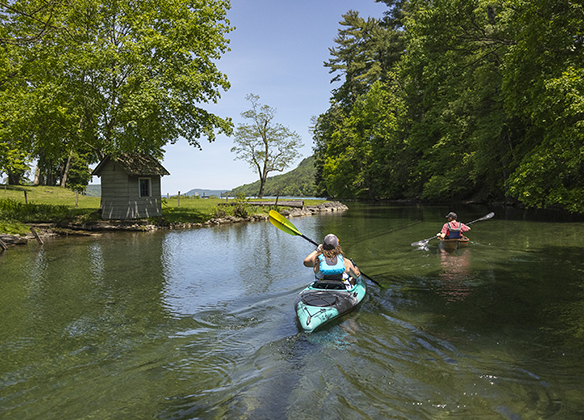
With one portage and a slightly challenging take out, more experienced paddlers will enjoy the meandering twists and turns that begin the Susquehanna River’s long journey to the Chesapeake Bay. Depending on the river levels, parts of the river can be shallow in some areas and may require you to exit the boat and carry it. There are also several creek inlets, so you want to make sure to follow the river at these junctures.
WATERWAY: Susquehanna River
DIFFICULTY: Experienced
MILEAGE: 5.5 miles
HAZARDS: Downed trees can block the narrow channel
ACCESS POINTS:
Compton Bridge NYS DEC Fishing Access
Fish Road Launch

- Leaving from the Fish Road Boat Launch located next to Lake Front Park in the Village of Cooperstown, you will enter the lake and turn right for the short paddle toward the Susquehanna River.
- As you make the turn into the river, Clinton’s Dam Historical Marker will be on the left bank and Council Rock Park will be on your right. A series of homes line the high bank past the park.
- Passing under the Main Street Bridge, a short distance further you’ll paddle through the center arch of the historic Fernleigh Estate Stone Bridge.
- Once you get to the other side of the bridge, you can see the where Main Street crosses over the water. The Otsego Lake Dam, is just on the other side of that bridge. The take-out for the portage is river left just before the bridge.
- Walk up the grassy bank and cross the road, watching for vehicle traffic. Do not attempt to put-in just over the road, as the access is very steep. Look for the trail a little further down the woods to your right, and follow to the water where you will put in.
- As you continue, the river will wrap around the parking area for Basset Hospital and continue on, eventually passing under the Susquehanna Avenue Bridge. The stretch of river from here to the next access at Compton Bridge, has some of the Susquehanna’s most significant twists and turns.
- Note: You may encounter areas of rapids and varying water depths. In lower water, you may need to walk your boat, so be sure you have appropriate footwear to navigate the rocky riverbed.
- The next landmark you encounter will be the Cooperstown Sewer plant, river right. A short distance further Red Creek enters on the left, so be sure to paddle the right. The river continues to meander through farmland, where you will pass under a small bridge.
- The river will straighten slightly where it runs along the railroad tracks on your right. Rail Explorers USA run a tour on their pedal-powered vehicles along the railroad tracks, and they have a stop at the top of the high bank on the right side of the river near the Phoenix Road Bridge. Paddle under that bridge.
- A short distance further, you’ll paddle under the railroad bridge as it crosses over the river. Beyond that is the junction with Oaks Creek.
- The take-out at the Compton Bridge NYS DEC Fishing Access is just past the inlet, river left, just before Compton Bridge. Be careful when exiting the water. There are several large rocks that line the river bank and they can be muddy and slippery. After large rainfalls, the river may also move swiftly in this area, making it a more challenging exit. Be sure to assess conditions before beginning your paddle.
ACCESS POINT 1:
Compton Bridge NYS DEC Fishing Access
WATER TRAIL MILE: 448.8
WATERWAY: Susquehanna River
Left Side
ADDRESS:
184 County Highway 11C
Cooperstown, NY 13326
![]()
This access point is located under the Route 11C bridge just past the confluence with Oaks Creek. The current and rocky shoreline here make this take-out best suited to more experienced paddlers.
Marked with a New York State Department of Environmental Conservation (DEC) sign on Route 11C next to the railroad crossing, there is a small parking area for approximately 9 cars. The launch area is on the opposite side of the street from the parking area, so use caution when crossing the road with a watercraft. Occasionally, Rail Explorers can be seen, pedaling along the railroad tracks.
Compton Bridge Road (Route 11C) connects to Route 28, where you will find several dining and lodging options.


ACCESS POINT 2:
Fish Road Launch
WATER TRAIL MILE: 454.24
WATERWAY: Otsego Lake
South Side
ADDRESS:
Fish Road
Cooperstown, NY 13326
![]()
![]()
![]()
![]()
![]()
![]()
Located in the Village of Cooperstown, this launch is a short distance from the headwaters of the Susquehanna River and ideal for paddlers who want to put-in and take-out at the same location and explore Cooperstown. Nearby attractions include the National Baseball Hall of Fame, Fenimore Farm and Country Village, Leatherstocking Golf Course, and historic Otesaga Resort. There are also many nearby dining and lodging options.
The wide gravel launch is located at the end of the parking lot between the marina docks. While there is parking for approximately 35 vehicles, spaces fill up quickly on weekends. Additional parking is available at the Trolley lot. Boats will be inspected prior to launch, so they must be clear of all vegetation. Lake Front Park is right next to the launch and has picnic tables, making it a great spot for lunch. Lake Front Restaurant and the Glimmerglass Tour Boat Company are located at the marina next door, and kayak rentals are available there.
Fish Road launch hours are 5:30 am – 7:30 pm.
Paddlers should be aware of motorboats on the lake.


POINTS OF INTEREST:

National Baseball Hall of Fame and Museum
Located on Main Street in Cooperstown just 2 blocks south of the Fish Road Launch via Hoffman Lane, the hallowed home of America's pastime, the National Baseball Hall of Fame and Museum highlights the Cooperstown experience, as every fan’s “Field of Dreams.” An independent, nonprofit educational institution, the Hall of Fame and Museum fosters a deep appreciation of baseball and its place in history through interactive exhibits and special events. Visit year-round and experience the magic of Cooperstown.

Photo by Howard C. Ohlhous, hmdb.org
General Clinton's Dam Historical Marker
Located at the headwaters of the Susquehanna River, the bronze plaque affixed on a large boulder notes the located where a temporary dam was built by soldiers under the command of General James Clinton in the summer of 1779. The dam raised the level of the water in the lake. When the dam was broken, troops used the rush of water to propel their heavy supply boats down the lake to rendezvous with troops in Tioga.

Fernleigh Estate Stone Bridge
Built for Edward Clark of the Singer Sewing Machine Company in 1869, the bridge is part of the Fernleigh Estate. The estate featured an elaborate neo-classical mansion, an impressive Turkish bathhouse, terraced gardens, a swimming pool, and the bridge. The estate still stands and is still privately owned by the Clark family, but the bridge is open to the public to visit.